Guanaja, the island next to Roatán, seen from the space station
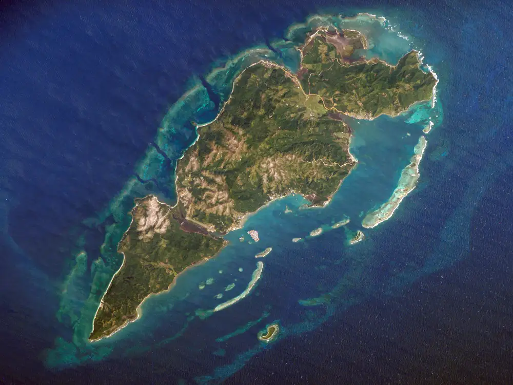
Look at a map of Roatán and there is another island just to the east that almost nobody mentions: Guanaja. In the photo at the top of this page it is seen from the International Space Station, on March 1, 2007. Same family of islands as ours, and a completely different story.
Where Guanaja is, and what it is made of
Guanaja sits in the western Caribbean, roughly 60 kilometres north of mainland Honduras, near the western edge of the Cayman Ridge, which NASA describes as “a topographic feature made of rock types that indicate ancient volcanic islands, sedimentary layers, and ocean crust.”
That ridge formed through tectonic interactions between the North American, South American and Caribbean Plates. And here is the detail that puts the Bay Islands in their proper place: Guanaja, Roatán and Utila are “the only portions of the western Cayman Ridge currently exposed above water.”
Put another way, when you walk at West Bay you are walking on the summit of an underwater mountain range. The three islands are the part that sticks out.
An island with almost no roads
This is where Guanaja genuinely differs from Roatán. It has stayed minimally developed, with one exception: settlement is concentrated on Bonacca Cay, a tiny island measuring roughly 0.5 by 0.3 kilometres off the southeastern coast.
The main island has no extensive roads or infrastructure. NASA writes that a canal is “the major means of traversing the island.” That makes it a destination for hikers and eco-tourists, and it explains why the name never appears in a cruise brochure.
For divers the case is simple: clear waters, and an island nearly completely encircled by reef.
Mitch’s scar
Then came 1998. Hurricane Mitch destroyed almost all of Guanaja’s mangrove forests. Coastal habitats were devastated, and soil erosion followed.
Scientists note that regeneration of mangroves is slow, and that active reseeding is essential for the forest to come back. More than twenty-five years later, that sentence from NASA is still the clearest measure of what Mitch cost the island.
It is a lesson for Roatán too. Mangrove is not scenery: it holds the soil in place and it is the nursery of the reef. The satellite images of Roatán, from 1973 to 2026 show that on our island the south coast mangrove did not fall to a hurricane, it is being cut. Different cause, same loss.
Guanaja and Roatán, two answers to the same question
Put the two NASA articles side by side and you get the cleanest natural experiment the Bay Islands have to offer:
- Roatán: over a million visitors a year, built-up land up 300% in thirty years, two cruise terminals, an expanded airport. Accessible, equipped, and loud at times.
- Guanaja: no roads, a canal, a village on a cay 500 metres across, a reef running the whole way around. Quiet, and far harder to reach.
Neither one is right. But if you have ever wondered what Roatán looked like before, the answer is not in an archive photo. It is 70 kilometres to the east, and people still live there.
Sources
- NASA Earth Observatory, Guanaja Island, Honduras, March 26, 2007. Astronaut photograph ISS014-E-15767, taken March 1, 2007 with a Kodak 760C digital camera and a 400 mm lens from the International Space Station.
- NASA Earth Observatory, How Tourism Changed the Face of Roatán, February 24, 2016, for the comparison with Roatán.
Want to see the Bay Islands as something other than a cruise pier? I live on Roatán and I build the days accordingly, in English, French or Spanish. Write to me or have a look at our tours.
Frequently asked questions
Where is Guanaja?
In the western Caribbean, roughly 60 kilometres north of mainland Honduras. It is the neighbour of Roatán and Utila, and together the three make up the Bay Islands.
What is the difference between Guanaja and Roatán?
Development. Roatán has cruise terminals, an expanded airport and roads. Guanaja has no extensive road network: according to NASA, the main way to traverse the island is a canal. Nearly all of the population lives concentrated on Bonacca Cay, an islet measuring roughly 0.5 by 0.3 kilometres.
What is Bonacca Cay?
A small cay of about 0.5 km by 0.3 km off the southeastern coast of Guanaja, where the island's settlement is concentrated. The main island itself has stayed largely undeveloped.
Why do divers go to Guanaja?
Clear waters, and an island that is almost completely encircled by its coral reef. The lack of development and roads also makes it attractive to hikers and eco-tourists.
What did Hurricane Mitch do to Guanaja?
Mitch, in 1998, destroyed almost all of the island's mangrove forests. Coastal habitats were devastated and soil erosion followed. Scientists note that regeneration of mangroves is slow and recommend active reseeding as essential for restoring the forest.
How do you get to Guanaja from Roatán?
Guanaja is Roatán's immediate neighbour in the Bay Islands. Most travellers land on Roatán first, since that is where the direct international flights arrive. Write to me before you book anything: inter-island connections change often, and I check what is actually running that week.